leste (p)
east (e)
est (f)
est (I)
este (S)
international date line
Let’s go back to the Prime Meridian, located in Greenwich, England. Heading East 180 degrees (or to the right) on a map or globe from the Prime Meridian, you will end up in the middle of the Pacific Ocean roughly at the location of the International Date Line. Conversely, heading West or to the left on a map of globe from the Prime Meridian, -180 degrees, you will also end up in the middle of the Pacific Ocean at the location of the International Date Line. The Prime Meridian and the line of longitude at 180 degrees, near the International Date Line, divide the Earth into the Eastern and Western hemispheres, just as the equator divides the Earth into the Northern and Southern hemispheres. The International Date Line was established at the same conference that established the Prime Meridian in 1884.
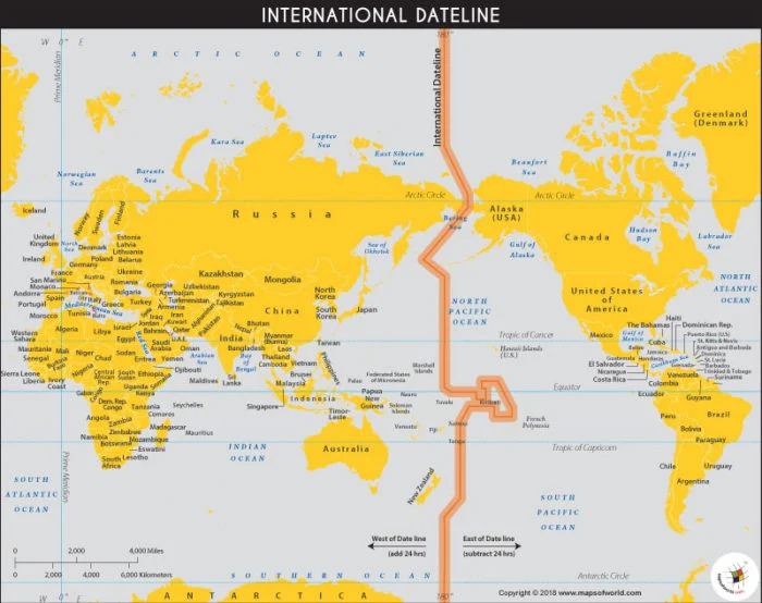
Because the Earth rotates and specifically, rotates to the East or counter-clockwise, longtitude and time measurement are connected. A movement of 15 degrees longitude is equal to a one-hour time difference in the local time. So, 15 degrees multiplied by 12 hours or half a day equals 180 degrees, halfway around the Earth. Crossing the date line eastbound decreases the date by one day, while crossing the date line westbound increases the date. The line is not always exactly at 180 degrees to prevent land areas from being in two different time zones. Check out the strange notch in the Pacific Ocean that allows Kiribati to be west of the International Date Line. And the line is much further east in the Bering Sea so that all of Russia is to the west of the line and all of the United States is to the east of the line.
Interestingly, that wasn’t always the case. In 1867, the United States purchased Alaska from Russia for $7.2 million dollars or 2 cents an acre (roughly $115 million in today’s dollars), a transaction sometimes labelled as Seward’s Folly after the U.S. Secretary of State who championed the purchase. In 1867, not everyone saw the potential of the territory (people weren’t thinking about gold, oil, salmon, Arctic influence, strategic importance, cruising and Deadliest Catch crabs back then). There was also concern about the giant country, Canada, in between Alaska and the Lower 48 (or “Outside” as Alaskans refer to the rest of the United States).
When the transfer from Russia to the United States took place, what day and time was it going to be in Alaska was a big issue. Since Alaska had been controlled by Russia, it used Russian time. To complicate things further, the Russians used the Julian calendar, which had a 12-day difference from the Gregorian calendar used in Europe and the United States. A change needed to be made to bring Alaska into United States time, something a bit like ripping off a bandage. The bandage was ripped off in present-day Sitka, Alaska on October 18, 1867, with the date changing by 12 days minus a day to account for Alaska being so much further East than Russia. Complicated enough for you?